View 2017 Heretaunga Plains Urban Development Strategy
View Maps of 2017 Heretaunga Plains Urban Development Strategy
The Heretaunga Plains of Hawke’s Bay are resource rich, and the value of the water and soil resources to the economy and the well-being of the community has changed little over time. However continual growth in the residential and industrial sectors has led to increasing competition for these resources.
The Heretaunga Plains Urban Development Strategy is the result of a collaborative approach by the Hastings District Council, Napier City Council and Hawke's Bay Regional Council towards managing urban growth on the Plains from 2015 to 2045. The joint Strategy was first adopted in 2010, then a reviewed version re-adopted by the three councils in early 2017 (HPUDS2017).
The original HPUDS2010 brought together the separate urban development strategies that both Hastings and Napier had in place from the 1990’s through to 2015. The revised HPUDS2017 updates the original joint strategy to accommodate and adapt to new growth projects, demographic changes and market drivers for housing and business land needs projected over the next 30 years.
When the 2010 version of HPUDS was adopted by the three councils, they had intended that the Strategy would be reviewed every five years to ensure it remained fit for purpose over time and adapted as necessary to remain relevant. As a consequence of the Government’s 2020 National Policy Statement on Urban Development (‘NPS UD’), regular 5 yearly reviews are no longer planned. Instead, the three councils’ efforts are refocussed on delivering a ‘Future Development Strategy’ (FDS) for the Napier Hastings urban area. The NPS UD requires the three councils to work together to prepare the FDS by 2024.
The area covered by HPUDS2017 and its 2010 predecessor includes Napier and Hastings cities and outlying suburbs, plus the small coastal and rural settlements from Whirinaki and Bay View to the fringes of the plains such as Maraekakaho, Puketapu and Pakipaki.
HPUDS2017 and its 2010 predecessor take into account a large number of global, national and local influences including climate change, peak energy, transport efficiency objectives, and national environmental standards plus, at a regional and local level, demographic and employment projections.
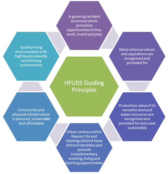
HPUDS is founded on a series of guiding principles:

Disclaimers and Copyright
While every endeavour has been taken by the Hawke's Bay Regional Council to ensure that the information on this website is
accurate and up to date, Hawke's Bay Regional Council shall not be liable for any loss suffered through the use, directly or indirectly, of information on this website. Information contained has been assembled in good faith.
Some of the information available in this site is from the New Zealand Public domain and supplied by relevant
government agencies. Hawke's Bay Regional Council cannot accept any liability for its accuracy or content.
Portions of the information and material on this site, including data, pages, documents, online
graphics and images are protected by copyright, unless specifically notified to the contrary. Externally sourced
information or material is copyright to the respective provider.
© Hawke's Bay Regional Council - www.hpuds.co.nz / / hpuds@hbrc.govt.nz